Top Ten Places on our Arctic Norway Cruise 2004
- Enga (66°42.5’N 013°42.85’E). (Snout of the Svartisen glacier). Exploring the glacier is an almost spiritual experience. Not to be missed on any account.
- Geirangerfjord. There is a good reason why this is the “most photographed fjord in Norway”. Spectacular.
- Steine (69°10.1’N 016°31.7’E). Anchorage in a small cluster of rocks 10 miles from the nearest land. Covered with birds. Exceptional.
- Aesoya anchorage (68°06.163’N 013°48.42’E). Picture book pretty with small sandy beach.
- Nusfjord (60°02.06’N 013°21.06’E). The loveliest of the Lofoten fishing villages.
- Straumshamm (68°06.4’N 015°22.3’E). Beautiful and wild anchorage complete with eagles.
- Villa Havn (64°32.7’N 010°42.4’E). In the skerries with terrific view from the top of the hill.
- Torghatten (mountain with the hole in the middle). Anchorage 20 minutess walk away is Moihavn (65°24.6’N 012°07’E)
- Renga (66°36’N 013°06’E). Delightful secluded anchorage.
- Grunnesundet (60°40.6’N 005°05.3’E). Tiny landlocked anchorage as if designed by landscape architect.
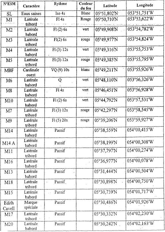
Buoyage entering the Maroni River – border of French Guiana and Suriname
The entrance to the river is very shallow and the 1.5m swell breaks over the sandbanks which can be unnerving. Our entrance was not made any easier by one of the red starboard hand buoys being 0.5nm out of position leading us into the shallows (it was buoy M3 which was at 05°49.981N 053°55.327W). Apparently the Surinamese fishermen have a habit of using the buoys to moor their boats and nets! The correct coordinates of where the buoys SHOULD be are: